Walk Map
Reference the accompanying guided walk map here. Turn-by-turn text directions coming soon.
Walk Details
- TIME: 9 a.m.-noon
- PACE: Conversational (1.5-2 miles per hour)
- TERRAIN: Sidewalks, paved multi-use paths, trail
- DISTANCE: 3.5 miles
- ELEVATION GAIN: 230’
- ACCESSIBILITY: Most of the route is stroller and wheelchair accessible; there are alternative paths when not. Viewpoint Trail along the base of Flagstaff Mountain is rocky and narrow with a 70-foot elevation gain, but not difficult.
Schedule and Planning
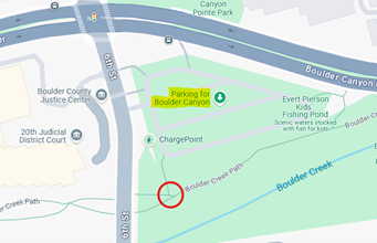
Meet in the parking lot across from the Boulder County Justice Center at Canyon Boulevard and 6th Street.
The starting point is accessible by bus, bike, walking or driving. Parking on Saturday is free. A BCycle station is next to the lot. Both the clockwise and counter-clockwise HOP bus routes stop nearby on 9th St. Many RTD routes stop on Broadway a few blocks from the starting point.
Walk Description
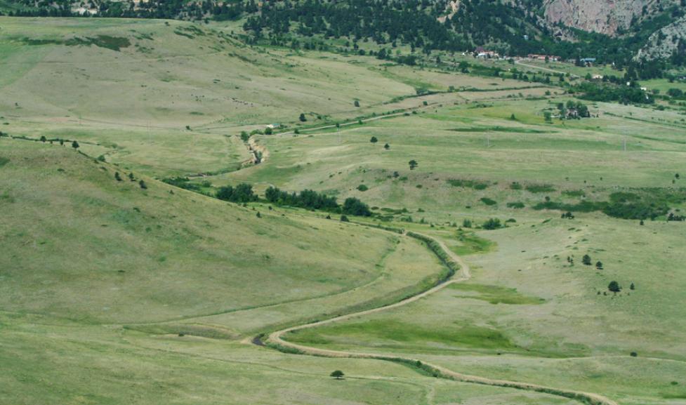
The Digging Boulder Walking Tour provides the opportunity to admire the great effort of carving strategic channels into this region’s rocky landscape to bring vital irrigation from Boulder Creek and Silver Lake, below Arapahoe Glacier, to the farmers of early Boulder. Today, these same ditches enable CSAs (Community Shared Agriculture), other farmers, ranchers, and localities to procure, store, and utilize water to produce harvests and sustain livestock. We will discuss the importance of ditch headgates, when and why they are opened, what those large horizontal wheels are and what they do, and the role of the dedicated ditch riders who operate them.
There are 70 ditches running 281 miles through the Boulder area covering more than 7,000 acres which are managed by OSMP. This new Boulder Walks Joy of Walking tour guides participants to six of these ditches and along Boulder Creek, which feeds five of them.
The loop begins at the Boulder County Justice Center parking lot at Canyon Blvd and 6th St. Parking is free on weekends. Heading west on Boulder Creek Path, the first stop will be Eben G. Fine Park at the beginning of Farmer’s Ditch, which runs northeast from Boulder Creek through Mapleton Hill, Old North Boulder, North Boulder, and through open space to Boulder Reservoir. Silver Lake Ditch, from the west, is just across the creek and runs parallel to Farmer’s Ditch before flowing up towards Red Rocks, along the north Boulder foothills, and on to the Mesa Reservoir. The Digging Boulder walk tour turns south to the Anderson Ditch alongside the foothills of Flagstaff Mountain. This ditch flows into University Hill through Columbia Cemetery and then to the southeast. The walk route tracks Anderson Ditch along Pennsylvania Avenue to 11th Street before turning north through The Hill to the Smith & Goss, Boulder & White Rock, and North Boulder Farmers ditch headgates below Broadway in the Central Park area.
Notes:
- Dress for the weather and bring a water bottle, sunscreen, and a camera. Sandals are not recommended on Viewpoint Trail.
- Gather near Boulder Creek Path next to the parking lot and begin at 9 a.m.
- Bike, BCycle, walk, drive, or take the Hop or a Skip RTD bus route for this walk.
- The route has accessible options along west Arapahoe Avenue and around Columbia Cemetery. Otherwise, it is stroller-friendly and appropriate for wheelchairs and ambulatory walkers. Overall elevation gain is 230 feet.
- Well-behaved dogs are welcome on 6' or shorter leashes.
- Restrooms are available in Eben G. Fine Park, near the ditch headgates by the Boulder Bandshell, and along Boulder Creek Path at 9th Street.
- On May 3, 2025, when arriving at the ditch headgates below Broadway, the Boulder Farmers Market will be ongoing between Arapahoe Avenue and Canyon Boulevard on 13th Street. Digging Boulder walkers are welcome to leave the guided walk to shop. Alternatively, finish the loop and return to the Farmers Market from the Justice Center parking lot.
This walk, Digging Boulder: A Tour of the Ditches that Helped Develop the City, highlights only a few of the 70 ditches managed by the Open Space & Mountain Parks Department. For more information, explore the following references:
- Ditches of Boulder interactive map with history and statistic links to each ditch.
- Carnegie Library for Local History, A day-long symposium on Western ditchers, 2009
Questions?
Contact Ericka Amador, Senior Transportation Planner at the City of Boulder: amadore@bouldercolorado.gov
Boulder Walks
This is a family-friendly walk guided by a Boulder Walks walk leader.