Learn About the Boulder Valley Comprehensive Plan

The City of Boulder and Boulder County invite you to help shape the future of the Boulder Valley. We are updating the Boulder Valley Comprehensive Plan, which guides how our community will look and feel, the mobility networks that connect us and how we approach changes to our natural and built environments for years to come. Join us over the next year as we discuss our biggest challenges, our greatest strengths and work toward a shared vision.

Together, we will create

Project Overview

The Boulder Valley Comprehensive Plan (PDF) seeks to protect the natural environment of the Boulder Valley while fostering a livable, vibrant and sustainable community. The plan provides an overview of the community’s desires for future development and preservation of the Boulder Valley. The city and county use it to guide long-range planning.

The major update will be the eighth major update to the plan, celebrating 50 years since its adoption. The plan that includes the fundamental framework to focus growth within the city where services and infrastructure exist was first approved in 1977. Since then, major updates have been completed in 1982, 1990, 1995, 2000, 2005, 2010 and 2017.

The updates give our community a chance to adjust the plan to reflect community values and needs, to address current challenges and to plan proactively for the future.

The Land Use Map shows the current land use designations for properties in the Boulder Valley.

Visit ABoulderFuture.org for the latest information about the major update and engagement opportunities.
What Does The Plan Do?

The aim of the first plan approved in 1977 was to concentrate urban development in the city and preserve the rural character of lands outside the city service area. Since then, the plan has evolved to also:

  • State the community's core values, commitments and long-term vision
  • Guide decisions about growth, development, preservation, environmental protection, economic development, affordable housing, culture and arts, urban design, neighborhood character and transportation
  • Inform decisions about how services like police, fire, water utilities and others are provided
  • Define the desired land use pattern for the Boulder Valley by establishing the location, type and intensity of development and setting land use designations
  • Offer a starting point the reflects our visions and values as the community develops strategies and policies to confront emerging issues and challenges
  • Serve as a foundation for city and countywide plans created by city and county departments to implement the goals of the plan

Background

What is the Boulder Valley? What communities are included?

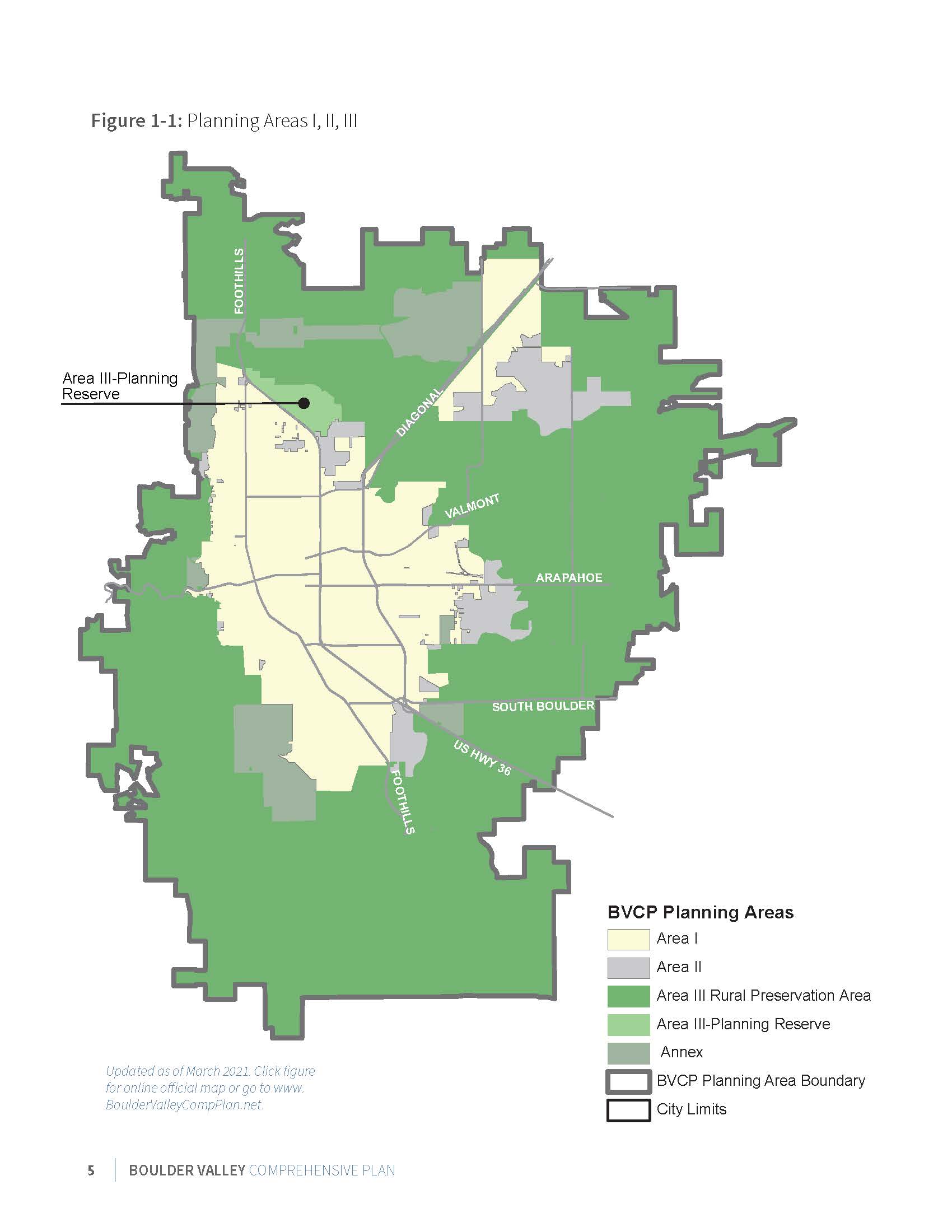
The plan affects a defined area the City of Boulder and portions of unincorporated Boulder County, including Gunbarrel and does not include or affect neighboring communities such as Louisville and Lafayette.

The Boulder Valley planning area is generally bounded by:

  • The mountains on the west
  • Neva Road and Niwot Road on the north
  • Mineral Road on the northeast
  • 95th Street on the east,
  • Davidson Mesa and the Coal Creek drainage on the southeast,
  • The south county line on the south

See map below for more details.

Map of Area I, II and III

View a larger version of this map in a separate window

2020 Mid-Term Update

The most recent mid-term update, a routine process to ensure the BVCP incorporated recent area plans and current maps, took place from 2020 to 2021. The mid-term update reviewed progress made toward the objectives identified in the last major plan update, provided an opportunity for the community to request changes to the plan that do not involve significant city and county resources and make minor additions or clarifications to the policy section.

What are Areas I, II and III?

Area I

Area I is an area within the City of Boulder. This land has adequate urban facilities and services and is expected to continue to accommodate urban development.

Area II

Area II is under Boulder County's jurisdiction, where annexation to the city could be considered. New urban development may only occur if adequate facilities and services are or will be available.

Area III

Area III is the remainder of the Boulder Valley and for the most part is in Boulder County. The Area III-Rural Preservation Area is preserved for rural land uses and character. The Area III-Planning Reserve Area is sub-area where the city and county maintain the option of future development.

Who Approves the Comp Plan? Who Writes It?

The community's elected leaders on the Boulder City Council and the Boulder County Board of County Commissioners, along with the city’s appointed Planning Board and county’s Planning Commission approve changes to the plan. These governmental bodies provide guidance to the City of Boulder's Planning & Development Services Department and Boulder County's Community Planning & Permitting Department, which conduct public outreach, do research and draft the plan.

Further Information & Maps

Sustainability, Equity and Resilience (SER) Framework

The framework explicitly identifies the community’s values expressed in the BVCP.

Community Profile

The Boulder Community Profile gives an overview of the key indicators and trends of Boulder population, housing, jobs, and land use.